200 Quilts · Four-in-Art · Quilts

Childhood’s Wide Avenues

4-in-art_3

Childhoods Wide Avenues Art Quilt_front

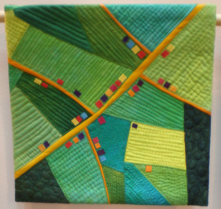
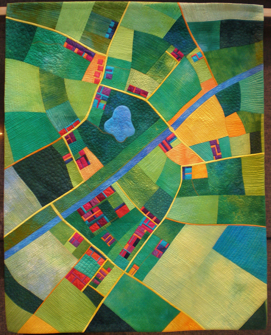
Childhood’s Wide Avenues is a quilt about memory, of fixing in time a place and a feeling.  I grew up in the mountain west, in Provo, Utah, a town laid out in a grid of wide avenues, criss-crossed with streets that seemed to me to be wide as the sky, although I’m sure if I went back there now, they would be reduced in size and dimension.  But that feeling that I could ride my bike to the top of the street near our house and see all the way down to my elementary school, or across the valley, or to the other side of the world has remained in my memory.

The possibilities were infinite.

ChildhoodWideAvenues Art Quilt_label

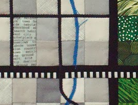
A few weeks ago, as I was thinking about this quilt and how to express the theme of Urban/Maps, I found myself traveling down another very wide avenue through the middle of a town very unlike where I grew up: San Bernardino, California.  But the boulevard was so wide and so straight and I could see it head in a straight line for miles, up into the foothills, that I felt as if I had been transported in an instant back to an earlier place and time.  But it seemed impossible, until I learned that Mormon pioneers, a branch off the same tree that laid out Provo, had also laid out the wide avenues of this town two states away, in the early 1850s.  Asked to settle this place far from their original homes in the Utah valley, they laid out a grid of wide avenues, and gave them names like Salt Lake Street,  Kirtland Street, Nauvoo Street, and Utah Street.  These have all been renamed, but those early pioneers left their stamp on the valley not only by naming the cemetery Pioneer Cemetery, but by etching long, wide avenues into the landscape.

CWA_8 Me

I had heard about memory being triggered by sounds, and by smells, but never had experienced memory being triggered by a sense of space, of a geographical series of landmarks making headway into my childhood memories.  For days afterward, I thought of the family I grew up in, and found pictures to place on my quilt that evoked a sense of that time (that’s me, above).

CWA_7 detail front

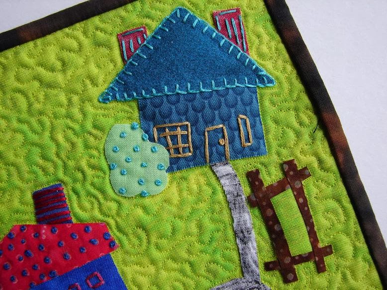
Who populates these fictional houses on my quilt?  The large pink house is my parents’ and the block below contains houses for my husband and I, and our four children and their families, while the blocks surrounding that central block are where my sisters and brothers might live. And because all of their spouses will want their own families, I scattered the grid of avenues with more houses, so that the circle of family would have place and space.  A dream, of course, as none of our children, nor any of my family live near us.  But in my world, in my memory, we are all there: gathering Easter eggs on the front lawn, jumping in piles of leaves, finding tarantulas in the fissures in the hillside, cracking open walnuts, and smelling the lilacs at the end of the driveway — lovely, amber-colored scenes.

Tomorrow I’ll deconstruct the quilt, describing the technical side of how I put it together.  But for now, more quilts depicting this theme of Urban/Maps can be found at:

Leannemap

Leanne of She Can Quilt

RachelHouse1

Rachel of The Life of Riley

BettyMap

Betty from her Flickr site

AmandaMap

Amanda of What the Bobbin?

NancyMap

Nancy of Patchwork Breeze

Annemap

Anne of SpringLeaf Studios

CarlaMap

Carla of Lollyquiltz

˚˚˚˚˚˚˚˚˚˚˚˚˚˚˚˚˚˚˚˚˚˚˚˚˚˚˚˚˚˚˚˚˚˚˚˚˚˚˚˚˚

FinishALong Button

This is a finished goal on my Quarter Three of the 2013 Finish-A-Long, hosted by Leanne of She Can Quilt.

It is also Quilt # 124 on my 200 Quilts List.

Four-in-Art · Quilts · Something to Think About

Map Musings

4-in-art_3Since the quarterly reveal date for our Four-In-Art is coming up in a couple of days, I thought it was high time to sit down and think about this new overall theme of Urban, and the specific quarterly theme of Maps.

Front Page TM

While we love the old maps, shown above on the front page of our family’s  travel blog, we all depend on recently updated maps to find our way around.  I read somewhere (and of course I can’t find it now,) that at some point in history, maps were kept only for those who had money or a position, guaranteeing them power over the masses who toiled in medieval fields.  For to hold a map, and to read it, is to understand your place in the world and how you relate to it.

SM Aerial Map Quilt

(Alicia Merritt, Green and Pleasant Land)

In a section of  Nicholas Carr’s book The Shallows: What the Internet is Doing to Our Brains, he writes about how maps develop:

“We progress from the infant’s egocentric, purely sensory perception of the world to the young adult’s more abstract and objective analysis of experience.”  Children’s drawings of maps advance as 1) simple topographical relationships are presented, without regard for perspective or distances, then 2) intellectural realism evolves connecting what is known with the proportional relationships, then 3) a visual realism appears.

Carr recounts that first maps were rudimentary, then realistic, then scientific in both precision and abstraction.  In addition, maps expressed ideas: ” ‘The intellectural process of transforming experience in space to abstraction of space is a revolution in modes of thinking,’ writes Vincent Virga, an expert on cartography affiliated with the Library of Congress.”

TV Map of USA

While no one under the age of 40 will remember this, once it was common when someone was coming to your house, for them to call you with the question, “How do I get to your house?”  Then we’d detail for them the streets to turn on and the landmarks to notice so they could arrive at our home.  Then came MapQuest, then Google Maps, then maps on our phones where can follow the little blue dots, then the aggravation with Apple’s Maps, proving again that he who holds an accurate map has real power.

Nighttime Map over USA

While this is a blurry shot of a city from an airplane, the first maps were of the heavens–of stars and planets and their movement.

LG Aerial Map Quilt

(Alicia Merrett, Canal Country)

Only later did it invert, so that maps became aerial views of the earth and its landmarks.

Creative Class Workers by Census Map(from the Santa Monica Patch: type in your USA city and see what you see)

Thiebaud Levee FarmWayne Theibaud, Levee Farms

Land Patterns from the air

Don’t we all have multiples of this photo on our cameras?  Aren’t we all amazed by the patterns on our earth, invisible to us as we drive/move/walk around at ground level?

Capturing a View National Portrait Gallery

(view towards the Archives, taken from the National Portrait Gallery, Washington, D.C.)

Maps can also be a window on our lives.

ESE Life Map 1a

I once had a class do Life Maps, where they depicted an aspect of their life, wrote a paper about it, and presented the map to the class.  This was my sample map of my education.  In writing in my art journal last night about maps, I began to realize that maps could also freeze time, evoke a memory.  Unlike my other Four-in-Arters, who seem to be charging ahead, I’ve been at a loss about what to make, how to proceed.  But after sitting down and writing about it, gathering pictures of maps and ideas, I am now creating my own map of where to go with this project.

*******

We are welcoming four new members this year, so the logo, which originally meant four artists, now has — at the suggestion of one of our group — changed to mean the four quarterly challenges we make. We reveal a new over-arching theme in August, then in November, February, April and August we make quilts around that theme, with smaller “subset themes” to guide us.  We hope you’ll come back on November 1st to take a quilt art tour, as the eight of us interpret our current theme of Urban/Maps.